Did the Final Act of the Congress of Vienna Define Switzerland's International Borders? Myth or Reality?
An analysis of the formation of the Swiss Confederation's territory through historical boundary markers
 “The current outline of Switzerland’s borders was established at the Congress of Vienna in 1815 but often dates back to a much earlier period,” states the Historical Dictionary of Switzerland. Frequently, the Congress of Vienna of 1815 is credited as the sole origin of Switzerland's modern borders. Indeed, enthusiasts tracing international boundary markers will encounter many stones installed in the years following the Congress of Vienna. However, along the way, they also find markers from the Ancien Régime predating the French Revolution. So, to what extent do the current borders stem from the Congress of Vienna? Or do they rather hark back to the era of the Ancien Régime?
To answer these questions, we first examine the text of the Final Act of the Congress of Vienna as it pertains to Switzerland. We also analyze the third paragraph of the first article of the Treaty of Paris dated November 20, 1815, which incorporates the consequences of France's defeat at Waterloo, subsequent to the Congress of Vienna. Next, we study the situation of Switzerland under the Ancien Régime. At the time, the Helvetic area perceived by the powers exceeded the territory of the 13-canton Confederation. Finally, we aim to determine whether a straightforward formulation exists to reconcile observations of current boundary markers in the field with the acts of the Congress of Vienna.
The Swiss Confederation Established by the Congress of Vienna
The Congress of Vienna took place in the Austrian capital from September 18, 1814, to June 9, 1815. The Kingdom of France, along with the Allied Powers victorious over Napoleon—Austria, Great Britain, Prussia, and Russia—reorganized the territories of European states following the upheaval of the Napoleonic Wars. Decisions concerning Switzerland are outlined in Articles 74 to 84 of the Final Act of the Congress of Vienna dated June 9, 1815 (Annex 1 and Figure 2, Annex 2 for the Treaty of Paris of May 30, 1814). The territory of the Swiss Confederation was expanded as follows:
- The 19 cantons existing in 1813 were recognized as members of the Helvetic body. These included the 13 original cantons and the 6 created by the Act of Mediation in 1803 with territorial adjustments up to 1813.
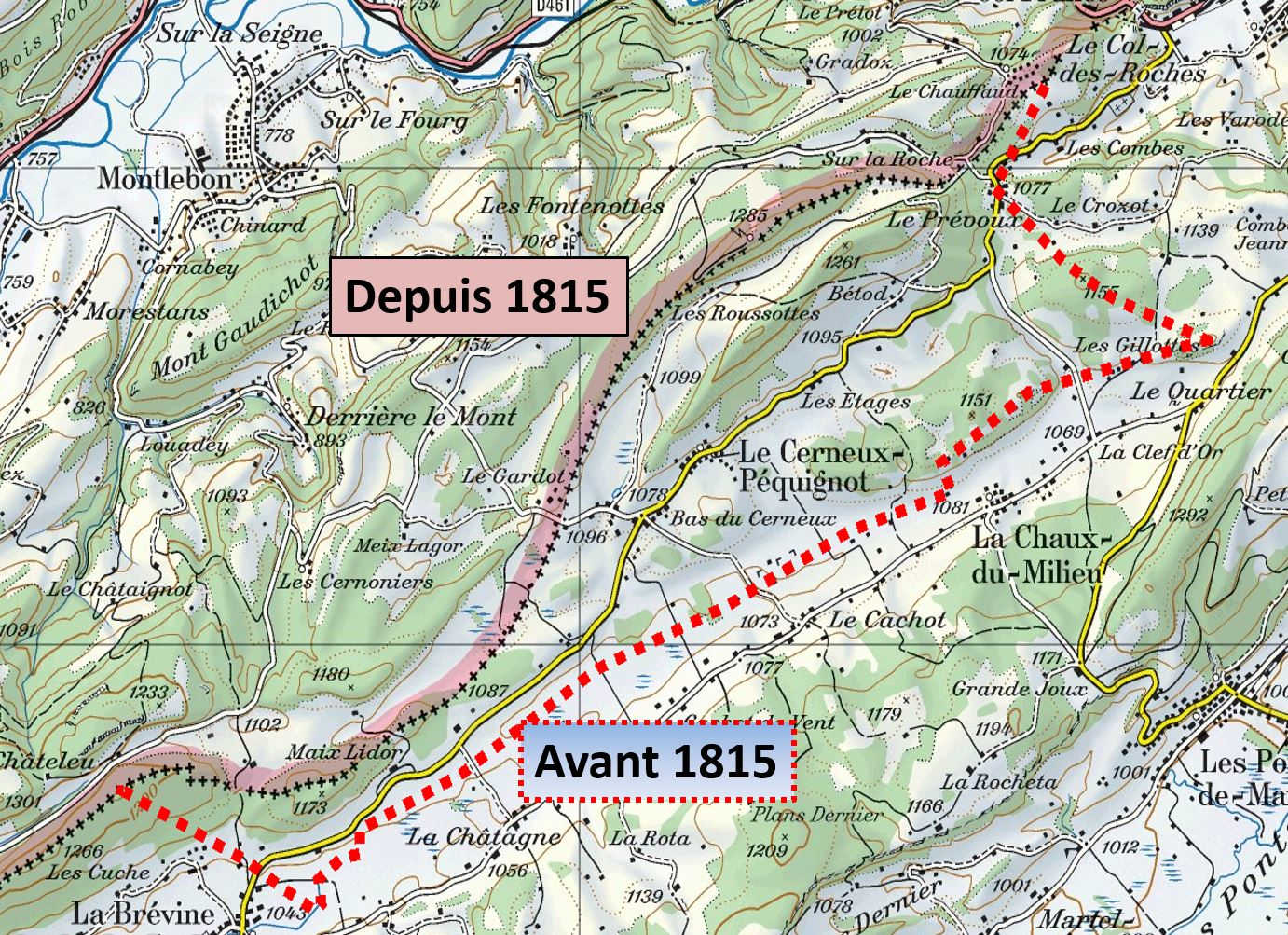
- Three new cantons—Geneva, Valais, and Neuchâtel—were added. Neuchâtel expanded with the commune of Cerneux-Péquignot. The canton of Vaud regained the Dappes Valley. Geneva acquired territories on the left bank of the Rhône to connect its historical holdings.
- The territories of the Bishopric of Basel (including the city of Biel) were incorporated into the Swiss Confederation. These did not form an independent canton but were divided among the cantons of Bern (mostly), Basel (one district), and Neuchâtel (the village of Lignières).
- The canton of Graubünden permanently acquired the Lordship of Rhäzüns.
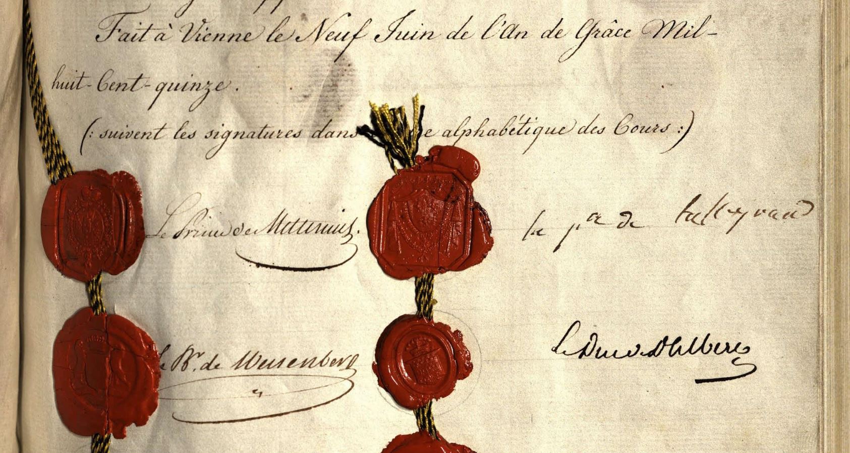
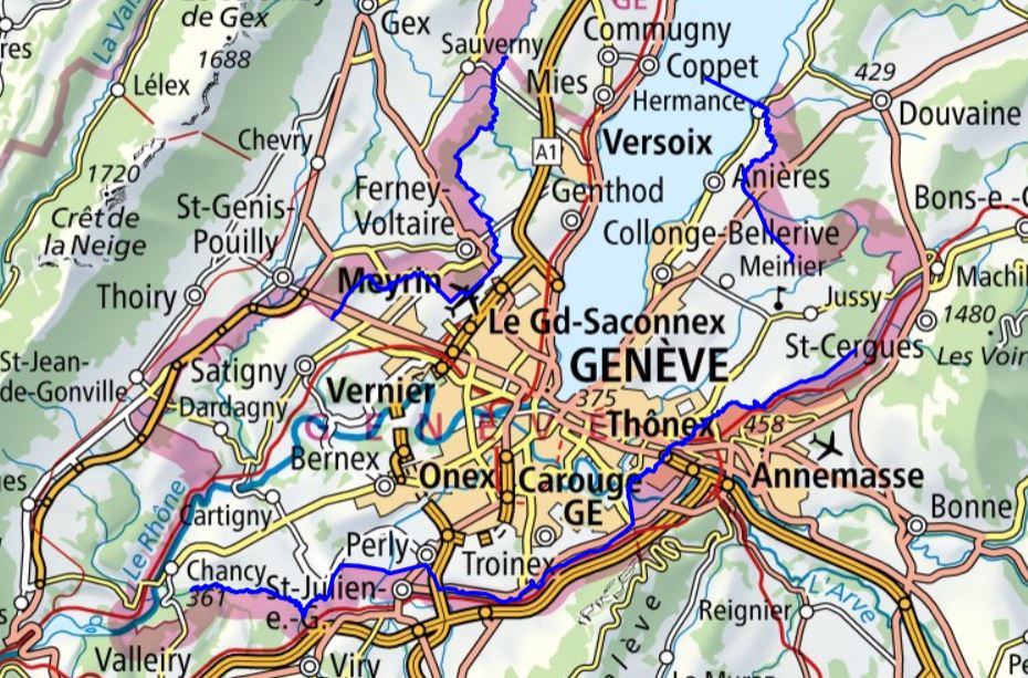
Following the Hundred Days and Napoleon's defeat at Waterloo, France was compelled to cede additional territories, particularly to allow Geneva to connect its historical holdings (Annex 3; Article 1 of the Treaty of Paris, November 20, 1815). Subsequently, the signatory powers of the Final Act of the Congress of Vienna recognized Switzerland's perpetual neutrality (Annex 4). For Geneva, the international border on the left bank of the Rhône took its definitive form with the Treaty of Turin on March 16, 1816 (Annex 5).
Unsurprisingly, the Congress of Vienna's decisions significantly impacted Switzerland's borders with France. Two new cantons (Neuchâtel and Geneva) and one territory (the Bishopric of Basel) defined a significant portion of the boundary between Switzerland and the Kingdom of France. Following the Treaty of Paris in 1815, systematic boundary marking of France's borders with its neighbors was required. Thus, between 1816 and 1825, the western border of Switzerland from Basel to Geneva was revised and marked. Boundary markers from this period bear dates corresponding to their respective cantons: Basel (1816), Solothurn and Bern (today Basel-Landschaft and Jura) (1817), Neuchâtel (1819), Vaud (1824), and Geneva (1818).
However, as France reverted to its 1790 borders, much of the French-Swiss international boundary aligned with historical limits. This border largely traced the boundaries of the former Kingdom of France with the cantons of Basel, Bern (Vaud), and Solothurn (members of the Old Confederation), as well as with the Principality of Neuchâtel, the Bishopric of Basel, and the Republic of Geneva (newly joined to the Confederation). Only the inclusion of Cerneux-Péquignot into Neuchâtel (Figure 3) and the Gessien communes into Geneva created a de facto new international route (Figure 4).
While France reverted to its 1790 borders, this was not the case for other boundaries of the newly 22-canton Swiss Confederation. The Fricktal, formerly Austrian, remained part of Aargau. In Graubünden, the Lordships of Rhäzüns and Tarasp became part of the canton, but Valtellina (including Bormio and Chiavenna), detached in 1797, did not return to Chur’s authority.
After 1815, Switzerland’s borders experienced only minor adjustments. The Treaty of the Dappes (December 8, 1862) and the Tirano Convention (August 27, 1863) resolved the last territorial disagreements. Subsequent changes were driven by infrastructure developments in transportation, energy, and tourism, involving exchanges of equivalent territorial areas.
The "Switzerland" of the Ancien Régime (16th–18th Century)
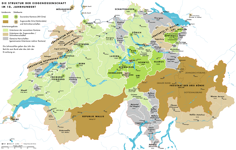
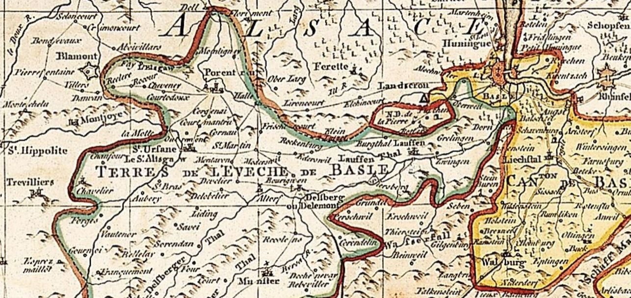
Pre-1798 Switzerland was a rather complex entity. European powers often did not perceive the extent of Swiss territory in the same way as members of the Confederation. The Swiss entity was characterized by a network of alliances and varying levels of subordination. Let us review these, focusing on the territories that today form Switzerland's borders (see also Annex 6). Starting with the core: as of 1513, the Confederation consisted of thirteen sovereign cantons: Zurich, Bern, Lucerne, Uri, Schwyz, Unterwalden, Glarus, Zug, Fribourg, Solothurn, Basel, Schaffhausen, and Appenzell. These cantons controlled, individually or jointly, several subject territories (e.g., Mendrisio since 1512). Allied territories (e.g., Geneva) supplemented the Swiss entity. Abraham Rouvier's map, printed in London in 1767 (Figure 5), illustrates the Switzerland of the Ancien Régime as "the thirteen Cantons, their Allies, and their Subjects." The map segment shows, for instance, the inclusion of the Bishopric of Basel’s lands within the Swiss sphere. This external perception of Switzerland is what we adopt for our study, as European powers made the decisions in Vienna.
Let us now identify, analyze, and count segments of the 1815 international boundary that already existed during the Ancien Régime. We will proceed clockwise, starting from Geneva. The Ancien Régime City and Republic of Geneva (an allied republic) had scattered territories disconnected from the city. The 1815 decisions addressed these discontinuities, as shown in Figure 4. From this, we can deduce the preserved older segments incorporated into the 1815 boundary. For the Vaud region (comprising Bernese bailiwicks from 1536 to 1798), the boundary shows remarkable stability, except for the Dappes Valley. Neuchâtel's boundary with Franche-Comté (excluding Cerneux-Péquignot) retains the outline negotiated by the Confederates during their occupation of the county between 1512 and 1529. The modern international borders of Jura and Basel-Landschaft reflect those negotiated by the Prince-Bishops of Basel. Solothurn and Basel consolidated their territories during the 16th century, and their western boundaries have remained fundamentally unchanged since.
For Switzerland’s northern border during the Ancien Régime, the cantons of Basel, Zurich, and Schaffhausen, along with the shared bailiwicks of Baden (1415–1798) and Thurgau (1460–1798), delineated what is now the German-Swiss border. Between these, Fricktal (part of Further Austria until 1801) joined the new canton of Aargau in 1803. Thus, the Rhine section between Leibstadt and Kaiseraugst was not an international boundary in the 18th century. In Schaffhausen, shared sovereignty over territories such as Epfenhofen, Gatterholz, and Wöschterholz was not resolved until 1839. Similarly, the Tägermoos (a 155-hectare area adjacent to the city of Constance), linked to the Swiss commune of Tägerwilen (TG), retains a hybrid status. The city of Constance continues to manage certain functions there, such as land registry and infrastructure maintenance.
From Constance, the international boundary crosses Lake Constance. The states bordering the lake considered the upper lake a shared resource. Thus, no valid international delimitation treaty exists for this portion of the boundary. During the Ancien Régime, the shared bailiwick of Thurgau (1460–1798), the Prince-Abbey of St. Gall (an allied territory), and the shared Rheintal bailiwick (1490–1798) bordered the lake. In this context, the 1815 Confederation adopted the boundaries or lack thereof that prevailed during the Ancien Régime.
Similarly, the section of the Rhine from Sargans to Lake Constance remained unchanged in 1815. The canton of St. Gallen (established in 1803) retained the boundaries of the shared Sarganserland bailiwick (1483–1798), the Glarus-controlled Werdenberg bailiwick (1517–1798), the Zurich-controlled Sax-Forstegg bailiwick (1615–1798), and the shared Rheintal bailiwick (1490–1798).
During the Ancien Régime, the Grison Leagues were an allied state of the Confederation, controlling a larger territory than in 1815. Between 1512 and 1797, the Valtellina, Bormio, and Chiavenna, as subject territories of the Three Leagues, formed the southern boundary of Graubünden. Thus, from Piz da las Trais Linguas (above Stelvio) to Sasso Bodengo (east of Roveredo), the 1815 boundary does not match that of 1790. At the end of Graubünden, we move to the international boundary of Ticino. Until 1798, Ticino consisted of eight subject bailiwicks of the Swiss cantons (1503/1521–1798). As such, the boundary saw no fundamental changes between 1790 and 1815. From Piccolo Corno Gries, we reach the international boundary of Valais. The Republic of the Seven Tithings conquered Lower Valais in two stages, in 1475 and 1536, placing the Valaisan southern boundary almost entirely along the modern route. Finally, the Treaty of Lausanne of 1564 between Bern and Savoy set the boundary between the two sovereignties at the middle of Lake Geneva.
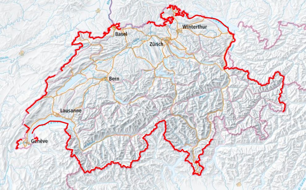
Figure 6 summarizes in red the segments of the 1815/16 international boundary that already existed in 1790. Most of the 1815 boundaries had previously been international borders. Between the situations of 1790 and 1815, differences are primarily seen in Geneva, Fricktal, and Graubünden. While Geneva’s changes stem from the Congress of Vienna (including the Treaties of Paris and Turin), Fricktal joined the Helvetic Republic in 1802 by Napoleon’s decree before becoming part of Aargau in 1803. Similarly, Napoleon annexed Valtellina (along with Bormio and Chiavenna) to the Cisalpine Republic in 1797, while Graubünden joined the Helvetic Republic in 1799.
Conclusion: Ancient Borders
The overview provided by Figure 6 demonstrates both geographically and visually that the boundaries of the 1815 Swiss Confederation are largely based on historical borders. As we have shown, the Swiss entity and its boundaries already existed during the Ancien Régime. In this context, the Congress of Vienna largely adopted historical boundaries rather than establishing new ones. Its more significant impact lay in the political reorganization of Swiss territory, streamlining its structure. By retaining the 1803 cantons, adding three new ones, and recognizing the country's neutrality, the Congress simplified, homogenized, and strengthened the Confederation. It became a unified entity of 22 cantons, with no subjects or allies. This provided European powers with a stable and neutral state that could act as a buffer against any resurgence of French expansionism.
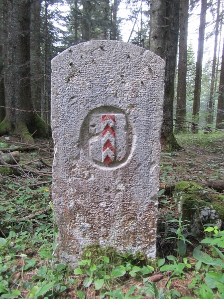
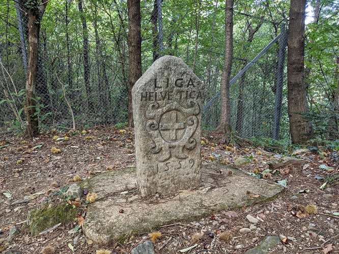
But where did these historical borders originate? Notably, Julius Caesar, in his writings from the 50s BCE, already described the land of the Helvetii as bounded by Lake Geneva, the Jura Mountains, and the Rhine. This general description by the proconsul of Gaul aligns closely with the western part of modern Switzerland. Such a historical flashback urges caution when attributing a single, modern origin to a border. Nonetheless, the 16th, 17th, and 18th centuries saw the refinement, structuring, and materialization of the boundaries we inherited, marked by the installation of numerous boundary markers. During this period, the mosaic of territories with overlapping rights inherited from the feudal era began consolidating into unified, sovereign states. As territorial administration developed (e.g., cadastral systems), states delineated their boundaries and marked them with boundary stones. Consequently, Switzerland’s international borders feature some markers from the 16th century (such as the one in Figure 7), more from the 17th century, and a significant number from the 18th century.
The French Revolution and its aftermath fundamentally reshaped Swiss territory. The armies of the French Republic invaded Switzerland in 1798, imposing the creation of a sister state, the Helvetic Republic, which marked the end of the Ancien Régime in Switzerland. By politically unifying the country, the Republic eliminated the old subjects and allies but did not include Geneva, Neuchâtel, the Bishopric of Basel, or Fricktal. The Act of Mediation of 1803 transformed the Helvetic Republic into a federal state of 19 cantons. This new Confederation incorporated the 13 original cantons and turned subject or allied territories into six new cantons (Aargau, Graubünden, St. Gallen, Ticino, Thurgau, Vaud). This structure was carried over to the Congress of Vienna in 1815. Since no major boundary marking occurred between 1798 and 1815, few physical markers from this period remain at the borders. Ultimately, the Congress of Vienna in 1815 was the last international conference to address Swiss territory. Its decisions were followed by significant boundary marking along the French border. Thus, in a sense, the Congress of Vienna represents the culmination of an evolution that spanned several centuries.
Annex 1
Articles 74 to 84 of the Final Act of the Congress of Vienna, June 9, 1815 [AT-OestA/HHSta UR AUR, 1815 VI 9 Schlussakten des Wiener Kongress]
Transcription of the handwritten document preserved in the Austrian State Archives in Vienna.
Art. LXXIV.
L'intégrité des dix-neuf Cantons, tels qu'ils existoient en Corps politique lors de la convention du 29 Décembre 1813, est reconnue comme base du système Helvétique.
Art. LXXV.
Le Valais, le territoire de Genève, la Principauté de Neuchâtel, sont réunis à la Suisse et formeront trois nouveaux Cantons. La vallée des Dappes, ayant fait partie du Canton de Vaud, lui est rendue.
Art. LXXVI.
L'Évêché de Bâle et la ville et le territoire de Bienne seront réunis à la Confédération Helvétique, et feront partie du Canton de Berne.
Sont exceptés cependant de cette dernière disposition les districts suivants :
1. Un district d'environ trois lieues quarrées d'étendue, renfermant les communes d'Altschweiler, Schönbuch, Oberweiler, Terweiler, Ettingen, Fürstenstein, Plotten, Pfeffingen, Aesch, Bruck, Reinach, Arlesheim, lequel district sera réuni au Canton de Basle ;
2. Une petite enclave située près du village Neufchâtellois de Lignières, laquelle étant aujourd'hui, quant à la juridiction civile, sous la dépendance du Canton de Neuchâtel, et quant à la juridiction criminelle, sous celle de l'évêché de Basle appartiendra en toute souveraineté à la Principauté de Neufchâtel.
Art. LXXVII.
Les habitans de l'Évêché de Bâle et ceux de Bienne, réunis au Canton de Berne et de Basle, jouiront à tous égards, sans différence de religion (qui sera conservée dans l'état présent) des mêmes droits politiques et civils dont jouissent et pourront jouir les habitans des anciennes parties desdits Cantons. En conséquence, ils concourront avec eux aux places de représentans, et aux autres fonctions, suivant les constitutions Cantonales. Il sera conservé à la ville de Bienne et aux villages ayant formé sa juridiction les privilèges municipaux compatibles avec la Constitution et les réglemens généraux du Canton de Berne.
La vente des domaines nationaux sera maintenue, et les rentes féodales et les dîmes ne pourront point être rétablies.
Les actes respectifs de réunion seront dressés, conformément aux principes ci-dessus énoncés, par des Commissions composées d'un nombre égal de députés de chaque partie intéressée. Ceux de l'Évêché de Bâle seront choisis par le canton directeur parmi les Citoyens les plus notables du pays. Lesdits actes seront garantis par la Confédération Suisse. Tous les points sur lesquels les parties ne pourront s'entendre, seront décidés par un arbitre nommé par la Diète.
Art. LXXVIII.
La cession qui avoit été faite par l'article III du Traité de Vienne, du 14 octobre 1809, de la seigneurie de Razüns, enclavée dans le pays des Grisons, étant venue à cesser, et Sa Majesté l'Empereur d'Autriche se trouvant rétabli dans tous les droits attachés à ladite possession, confirme la disposition qu'il en a faite, par déclaration du 20 mars 1815, en faveur du Canton des Grisons.
Art. LXXIX.
Pour assurer les communications commerciales et militaires de Genève avec le canton de Vaud et le reste de la Suisse, et pour compléter à cet égard l'article IV du Traité de Paris du 30 mai 1814, Sa Majeté Très-Chrétienne consent à faire placer la ligne de douanes de manière à ce que la route qui conduit de Genève par Versoy en Suisse, soit en tout tems libre, et que, ni les postes, ni les voyageurs, ni les transports de marchandises, n'y soient inquiétés par aucune des douanes, ni soumis à aucun droit. Il est également entendu que le passage des troupes suisses ne pourra y être aucunement entravé.
Dans les réglemens additionnels à faire à ce sujet, on assurera, de la manière la plus convenable aux Genevois l'exécution des Traités relatifs à leurs libres communications entre la ville de Genève et le Mandement de Peney. Sa Majesté Très-Chrétienne consent en outre à ce que la gendarmerie et les milices de Genève passent par la grande route du Meyrin dudit mandement à la ville de Genève, et réciproquement, après en avoir prévenu le poste militaire de la gendarmerie française le plus voisin.
Art. LXXX.
Sa Majesté le Roi de Sardaigne cède la partie de la Savoye qui se trouve entre la rivière d'Arve, le Rhône, les limites de la partie de la Savoye cédée à la France, et la montagne de Salève, jusqu'à Veiry inclusivement ; plus celle qui se trouve comprise entre la grande route dite du Simplon, le lac de Genève et le territoire actuel du canton de Genève, depuis Venezas jusqu'au point où la rivière d'Hermance traverse la susdite route, et de là, continuant le cours de cette rivière jusqu'à son embouchure dans le lac de Genève, au levant du village d'Hermance (la totalité de la route dite du Simplon continuant à être possédée par Sa majesté le Roi de Sardaigne) pour que ces pays soient réunis au canton de Genève, sauf à déterminer plus précisément les limites par des Commissaires respectifs, surtout ce qui concerne la délimitation en dessus de Veiry et sur la montagne de Salève, renonçant, Sadite Majesté, pour Elle et ses successeurs, à perpétuité, sans exception ni réserve, à tous droits de souveraineté et autres qui peuvent lui appartenir dans les lieux et territoires compris dans cette démarcation.
Sa majesté le Roi de Sardaigne consent en outre, à ce que la communication entre le Canton de Genève et le Valais, par la route dite du Simplon, soit établie de la même manière que la France l'a accordée entre Genève et le Canton de Vaud, par la route de Versoy. Il y aura aussi en tout temps une communication libre pour les troupes Genevoises entre le territoire de Genève, et le Mandement de Jussi, et on accordera les facilités qui pourroient être nécessaires dans l'occasion, pour arriver par le lac à la route dite du Simplon.
De l'autre côté, il sera accordé exemption de tout droit de transit à toutes les marchandises et denrées qui, en venant des États de Sa Majesté le Roi de Sardaigne et du port franc de Gênes, traverseraient la route dite du Simplon dans toute son étendue par le Valais et !'État de Genève, Cette exemption ne regardera toute fois que le transit, et ne s'étendra ni aux droits établis pour l'entretien de la route, ni aux marchandises et denrées destinées à être vendues ou consommées dans l'intérieur. La même réserve s'appliquera à la communication accordée aux Suisses entre le Valais et le Canton de Genève, et les Gouvernemens respectifs prendront à cet effet, de commun accord, les mesures qu'ils jugeront nécessaires, soit pour la taxe, soit pour empêcher la contrebande chacun sur son territoire.
Art. LXXXI
Pour établir des compensations mutuelles, les Cantons d'Argovie, de Vaud, du Tessin et de St Gall, fourniront aux anciens cantons de Schwitz, Unterwald, Uri, Glaris, Zug et Appenzell (Rhode intérieure) une somme qui sera appliquée à l'instruction publique et aux frais d'administration générale, mais principalement au premier objet dans lesdits Cantons.
La quotité, le mode de payement et la répartition de cette compensation pécuniaire, sont fixés ainsi qu'il suit :
Les Cantons d'Argovie, de Vaud et de St Gall fourniront aux Cantons de Schwitz, Unterwald, Uri, Zug, Glaris et Appenzell (Rhode intérieure) un fonds de 500,000 livres de Suisse.
Chacun des premiers payera l'intérêt de sa quote-part à raison de 5 pour cent par an, ou remboursera le capital, soit en argent, soit en biens-fonds, à son choix
La répartition, soit pour le payement, soit pour la recette de ces fonds, se fera dans les proportions de l'échelle de contribution réglée pour subvenir aux dépenses fédérales.
Le canton du Tessin payera chaque année au Canton d'Uri la moitié du produit des péages dans la vallée Levantine.
Art. LXXXII
Pour mettre un terme aux discussions qui se sont élevées par rapport aux fonds placés en Angleterre par les Cantons de, Zuric et de Berne, il est statué :
1. Que les Cantons de Berne et de Zuric conserveront la propriété du fonds capital, tel qu'il existoit en 1803, à l'époque de la dissolution du Gouvernement Helvétique, et jouiront, à dater du 1er Janvier 1815, des intérêts à échoir ;
2. Que les intérêts échus et accumulés depuis l'année 1798 jusques et y compris l'année 1814, seront affectés an payement du capital restant de la dette nationale, désignée sous la dénomination de dette Helvétique ;
3. Que le surplus de la dette Helvétique restera à la charge des autres Cantons, ceux de Berne et de Zuric étant exonérés par la disposition ci-dessus. La quote-part de chacun des Cantons qui restent chargés de ce surplus, sera calculée et fournie dans la proportion fixée pour les contributions destinées au payement des dépenses fédérales ; les Pays incorporés à la Suisse depuis 1813, ne pourront pas être imposés en raison de l'ancienne dette Helvétique.
S'il arrivait qu'après le payement de la susdite dette il y eût un excédant, il seroit réparti entre les Cantons de Berne et de Zuric dans la proportion de leurs capitaux respectifs.
Les mêmes dispositions seront suivies à l'égard de quelques autres créances, dont les titres sont déposés sous la garde du Président de la Diète.
Art. LXXXIII
Pour concilier les contestations élevées à l'égard des Lands abolis sans indemnité, une indemnité sera payée aux particuliers propriétaires des Lands. Et afin d'éviter tout différend ultérieur à ce sujet entre les Cantons de Berne et de Vaud, ce dernier payera au Gouvernement de Berne la somme de trois cent mille livres de Suisse, pour être ensuite répartie entre les ressortissants Bernois, propriétaires des Lands. Les payemens se feront à raison d'un cinquième par an, à commencer du 1er janvier 1816.
Art. LXXXIV
La déclaration adressée, en date du 20 Mars, par les Puissances qui ont signé le Traité de Paris, à la Diète de la Confédération Suisse, et acceptée par la Diète moyennant son acte d'adhésion du 27 mai, est confirmée dans toute sa teneur, et les principes établis, ainsi que les arrangemens arrêtés dans ladite déclaration, seront invariablement maintenus.
Annex 2
Article 3, Paragraphs 6 and 7 of the Treaty of Paris, May 30, 1814 [BnF Gallica, excerpt from the Moniteur, June 2, 1814, No. 155]
6. Dans le département du Doubs, la frontière sera rectifiée de manière à ce qu'elle commence au-dessus de la Rançonnière, près du Locle, et suive la crête du Jura, entre le Cerneux-Péquignot et le village de Fontenelles, jusqu'à une cime du Jura située à environ sept ou huit mille pieds au nord-ouest du village de la Brévine, où elle retombera dans l'ancienne limite de la France.
7. Dans le département du Léman, les frontières entre le territoire Français, le pays de Vaud et les différentes portions du territoire de la République de Genève (qui fera partie de la Suisse), restent les mêmes qu'elles étaient avant l'incorporation de Genève à la France. Mais le canton de Frangy, celui de Saint-Julien (à l'exception de la partie située au nord d'une ligne à tirer du point où la rivière de la Laire entre, près de Chancy, dans le territoire Genevois, le long des confins de Seseguin, Lacouex et Seseneuve, qui resteront hors des limites de la France), le canton de Reignier (à l'exception de la portion qui se trouve à l'Est d'une ligne qui suit les confins de la Muraz, Bussy, Pers et Cornier, qui seront hors des limites Françaises), et le canton de la Roche (à l'exception des endroits nommés la Roche et Armanoy, avec leurs districts), resteront à la France. La frontière suivra les limites de ces différents cantons et les lignes qui séparent les portions qui demeurent à la France de celles qu'elle ne conserve pas.
Annex 3
Article 1, Paragraphs 3 and 6 of the Treaty of Paris, November 20, 1815 [BnF Gallica, excerpt from the Moniteur, November 26, 1815, No. 330]
3. Pour établir une communication directe entre le canton de Genève et la Suisse, la partie du pays de Gex, bornée à l'est par le lac Léman, au midi par le territoire du canton de Genève, au nord par celui du canton de Vaud, à l'ouest par le cours de la Versois et par une ligne qui renferme les communes de Collex-Bossy et Meyrin, en laissant la commune de Ferney à la France, sera cédée à la confédération helvétique, pour être réunie au canton de Genève. La ligne des douanes françaises sera placée à l'ouest du Jura, de manière que tout le pays de Gex se trouve hors de cette ligne.
6. Les hautes parties contractantes nommeront dans le délai de trois mois, après la signature du présent traité, des commissaires pour régler tout ce qui a rapport à la délimitation des pays de part et d'autre ; et aussitôt que le travail de ces commissaires sera terminé, il sera dressé des cartes et placé des poteaux qui constateront les limites respectives.
Annex 4
Excerpt from the Declaration of the Powers Recognizing and Guaranteeing the Perpetual Neutrality of Switzerland and the Inviolability of its Territory, November 20, 1815, Paris [AT-OestA/HHSta UR AUR, 1815 XI 20 Anerkennung und Garantie der immerwährenden Neutralität der Schweiz]
Transcription of the handwritten document preserved in the Austrian State Archives in Vienna
[…] Ces changements se trouvant désormais déterminés par les stipulations du Traité de Paris de ce jour, les Puissances signataires de la déclaration de Vienne font par le présent acte, une reconnaissance formelle et authentique de la neutralité perpétuelle de la Suisse, et elles lui garantissent l'intégrité et l'inviolabilité de son territoire dans ses nouvelles limites, telles qu'elles sont fixées, tant par l'acte du Congrès de Vienne que par le Traité de Paris de ce jour, et telles qu'elles le seront ultérieurement, conformément à la disposition du 3 novembre ci-joint en extrait qui stipule en faveur du corps helvétique un nouvel accroissement de territoire à prendre sur la Savoie pour arrondir et désenclaver le canton de Genève. […]
Annex 5
Article 1 of the Treaty of Turin, March 16, 1816 [AEG Savoie 37]
Transcription of the handwritten document preserved in the State Archives of Geneva
Le territoire cédé par S. M. le roi de Sardaigne, pour être réuni au Canton de Genève, soit en vertu des Actes du Congrès de Vienne du 29 Mars 1815, soit en vertu des dispositions du Protocole des Puissances Alliées du 3 Novembre suivant, et du Traité de ce jour, est limité, par le Rhône, à partir de l'ancienne frontière près de Saint-Georges, jusqu'aux confins de l'ancien territoire genevois, à l'ouest d'Aire-la-ville; de là, par une ligne suivant ce même ancien territoire, jusqu'à la rivière de la Laire; remontant cette rivière jusqu'au chemin qui, de la Perrière tend à Soral; suivant ce chemin jusqu'au dit Soral, lequel restera, ainsi que le chemin, en entier sur Genève; puis par une ligne droite, tirée sur l'Angle Saillant de la commune de Bernex, à l'ouest de Norcier. De cet Angle, la limite se dirigera par la ligne la plus courte à l'angle méridional de la commune de Bernex sur l'Aire, laissant Norcier et Turens sur Savoie. De ce point, elle prendra la ligne la plus courte pour atteindre la commune de Compesières; suivra le confin de cette commune, à l'est de Saint-Julien, jusqu'au ruisseau de l'Arande qui coule entre Ternier et Bardonnex; remontera ce ruisseau jusqu'à la grande route d'Annecy à Carouge; suivra cette route jusqu'à l'embranchement du chemin qui mène directement à Collonge, à cent cinquante-cinq toises de Savoie avant d'arriver à la croix de Roson; atteindra, par ce chemin, le ruisseau qui descend du village d'Archamp; suivra ce ruisseau jusqu'à son confluent avec celui qui descend du hameau de la Combe, au-dela d'Evordes, en laissant néanmoins toutes les maisons dudit Evordes sur Genève; puis du ruisseau de la Combe, prendra la route qui se dirige sous Bossey, sous Crevin, et au-dessus de Veirier. De l'intersection de cette route, à l'est et près de Veirier, avec celle qui, de Carouge tend à Etrembières, la limite sera marquée par la ligne la plus courte pour arriver à l'Arve, à 2 toises au-dessus de la prise d'eau du bief du moulin de Sierne. De là, elle suivra le thalweg de cette rivière jusques vis-à-vis de l'embouchure du Foron; remontera le Foron jusqu'au-delà de Cormières, au point qui sera indiqué par la ligne la plus courte tirée de la jonction de la route de Carra avec le chemin qui du nord de Puplinge tend au nord de Ville-la-grand; suivra ladite ligne, et ce dernier chemin vers l'est, en le donnant à Genève; puis la route qui remonte parallèlement au Foron, jusqu'à l'endroit où elle se trouve en contact avec le territoire de Jussy. De ce point, la ligne reprendra l'ancienne limite, jusqu'à sa rencontre avec le chemin tendant de Gy à Foncenex, et suvivra ledit chemin vers le nord, jusqu'à la sortie du village de Gy, laissant ledit chemin sur Genève. La limite se dirigera ensuite en ligne droite sur le village de Veigy, de manière à laisser toutes les maisons du village sur Savoie; puis en ligne droite au point où l'Hermance coupe la grande route du Simplon. Elle suivra enfin l'Hermance jusqu'au lac, lequel bornera le nouveau territoire au nord-ouest : bien entendu que la propriété du lac, jusqu'au milieu de sa largeur, à partir d'Hermance jusqu'à Vésenaz, est acquise au Canton de Genève, et qu'il en sera de même des portions du cours du Rhône qui, ayant fait jusqu'ici frontière entre les deux Etats, appartenaient à S. M.; que tous les chemins indiqués comme formant la ligne frontière dans la délimitation ci-dessus, appartiendront à S. M., sauf les exceptions indiquées; et que tous les enclos fermés de murs ou de haies, attenans aux maisons des villages ou hameaux qui se trouveraient placés près de la nouvelle frontière, appartiendront à l'état dans lequel est situé le village ou hameau : la ligne marquant les confins des états ne pourra être rapprochée à plus de deux toises des maisons ou des enclos y attenans, et fermés de murs ou de haies. Quant aux rivières et ruisseaux qui, d'après les changements de limites résultans du Traité de ce jour, déterminent la nouvelle frontière, le milieu de leur cours servira de limite, en exceptant le Foron, lequel appartiendra en entier à S. M. et dont le passage ne sera assujetti à aucun droit.
Annex 6
Map of 18th-Century Switzerland [Marco Zanoli, 2006]
